Atm nearby ANZ ATM Belmont Centro
Australia
Atm nearby ANZ ATM Belmont Centro
ANZ ATM Belmont Centro
1/65 High Street, Belmont Australia
contacts phone
:
+61
Latitude:
-38.170354
, Longitude:
144.348538
read more
nearest Atm
69 m
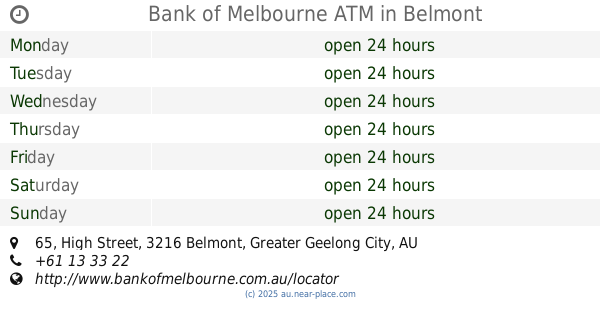
Bank of Melbourne ATM
65 High Street, Belmont
Atm
read more
95 m
Bendigo and Adelaide Bank Limited ATM
65 High Street, Belmont
Atm
read more
688 m
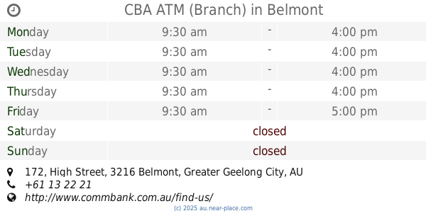
CBA ATM (Branch)
172 High Street, Belmont
Atm
read more
703 m
ANZ ATM Belmont (Smart)
167 High Street, Belmont
Atm
read more
726 m
rediATM
176 High Street, Belmont
Atm
read more
728 m
NAB ATM
176 High Street, Belmont
Atm
read more
1.002 km
the middle of a river
Promenade, Belmont
Atm
read more
1.181 km
Cashcard ATM
120 Fyans Street, South Geelong
Atm
read more
1.366 km
rediATM
358/360 Pakington Street, Newtown
Atm
read more
1.37 km
BOQ ATM
358/360 Pakington Street, Newtown
Atm
read more
1.472 km
rediATM
367 Moorabool Street, South Geelong
Atm
read more
2.123 km
FCCS Credit Union
107 Gheringhap Street, Geelong
Atm
read more
2.171 km
People's Choice Credit Union - Impressions In Hair - ATM
4 Belle Vue Avenue, Highton
Atm
read more
2.171 km
rediATM
4 Belle Vue Avenue, Highton
Atm
read more
2.554 km
People's Choice Credit Union - ATM
east 3219, 78 Garden Street, Geelong
Atm
read more
2.554 km
People's Choice Credit Union - Geelong East - ATM
east 3219, 78 Garden Street, Geelong
Atm
read more
2.565 km
rediATM
Garden Street, East Geelong
Atm
read more
2.646 km
Bankwest ATM
115 Moorabool St, Geelong
Atm
read more
2.668 km
Cashcard ATM
119 Moorabool Street, Geelong
Atm
read more
2.699 km
Cashcard ATM
38 Bellerine Street, Geelong
Atm
read more
2.726 km
CBA ATM (Market Square Shopping Centre - Lvl 1)
Moorabool Street, Geelong
Atm
read more
2.815 km
Westpac ATM
Ground Floor/125 Malop Street, Geelong
Atm
read more
2.89 km
Bank of Melbourne ATM
Shop 1190 95 Malop St, Geelong
Atm
read more
2.93 km
rediATM
Australia
Atm
read more
2.952 km
Cashcard ATM
42 Moorabool Street, Geelong
Atm
read more
📑
all categories
Accounting
Administrative area level 1
Administrative area level 2
Airport
Amusement park
Aquarium
Art gallery
Atm
Bakery
Bank
Bar
Beauty salon
Bicycle store
Book store
Bowling alley
Bus station
Cafe
Campground
Car dealer
Car rental
Car repair
Car wash
Casino
Cemetery
Church
City hall
Clothing store
Colloquial area
Convenience store
Courthouse
Dentist
Department store
Doctor
Electrician
Electronics store
Embassy
Finance
Fire station
Florist
Food
Funeral home
Furniture store
Gas station
General contractor
Grocery or supermarket
Gym
Hair care
Hardware store
Health
Hindu Temple
Home goods store
Hospital
Insurance agency
Jewelry store
Laundry
Lawyer
Library
Light rail station
Liquor store
Local government office
Locality
Locksmith
Lodging
Meal delivery
Meal takeaway
Mosque
Movie rental
Movie theater
Moving company
Museum
Natural feature
Neighborhood
Night club
Painter
Park
Parking
Pet store
Pharmacy
Physiotherapist
Place of worship
Plumber
Point of interest
Police
Political
Post office
Premise
Real estate agency
Restaurant
Roofing contractor
Route
Rv park, camping
School
Shoe store
Shopping mall
Spa
Stadium
Storage
Store
Subpremise
Subway station
Supermarket
Synagogue
Taxi stand
Train station
Transit station
Travel agency
University
Veterinary care
Zoo
↑