Bar nearby Morwell Central Bar & Bistro
Coronavirus disease (COVID-19) Situation
confirmed cases
11853144
deaths
24414
Australia
Bar nearby Morwell Central Bar & Bistro
Morwell Central Bar & Bistro
192, Commercial Road, 3840, Morwell, Latrobe City, AU Australia
contacts phone
:
+61 3 5133 0429
Latitude:
-38.2374895
, Longitude:
146.3971842
larger map & directions
read more
nearest Bar
199 m
Silver's Bar & Grill
3-5 Hazelwood Road, Morwell
Bar
read more
1.126 km
Morwell Hotel
311-327 Princes Drive, Morwell
Bar
read more
1.136 km
Top Pub
329 Princes Drive, Morwell
Bar
read more
1.153 km
Morwell Hotel Motel
Princes Drive, Morwell
Bar
read more
12.81 km
Turks Sports Bar
108/112 Hotham Street, Traralgon
Bar
read more
12.824 km
Royal Exchange Hotel
64 Princes Highway, Traralgon
Bar
read more
12.831 km
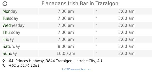
Flanagans Irish Bar
64 Princes Highway, Traralgon
Bar
read more
13.04 km
The 3844
47-49 Princes Street, Traralgon
Bar
read more
13.043 km
Kay Street Entertainment Complex (Saloon Bar & Inferno Nightclub)
19-23 Kay Street, Traralgon
Bar
read more
13.111 km
Crown Hotel
72 Franklin Street, Traralgon
Bar
read more
13.129 km
Kaptain 8-Ball
36 Hotham Street, Traralgon
Bar
read more
13.206 km
Ryans Hotel
171 Franklin Street, Traralgon
Bar
read more
13.231 km
Star Bar
27A Grey Street, Traralgon
Bar
read more
14.813 km
Stegbar
153 Argyle Street, Traralgon
Bar
read more
41.388 km
Newmason Eat Drink Relax
25 Mason Street, Warragul
Bar
read more
41.56 km
Warragul Sushi Bar
37 Smith Street, Warragul
Bar
read more
42.365 km
Warragul Country Club
41 Sutton St, Warragul
Bar
read more
42.365 km
Warragul Country Club
41 Sutton Street, Warragul
Bar
read more
48.516 km
Murphy's Law Bar
65 Princes Way, Drouin
Bar
read more
📑
all categories
Accounting
Administrative area level 1
Administrative area level 2
Airport
Amusement park
Aquarium
Art gallery
Atm
Bakery
Bank
Bar
Beauty salon
Bicycle store
Book store
Bowling alley
Bus station
Cafe
Campground
Car dealer
Car rental
Car repair
Car wash
Casino
Cemetery
Church
City hall
Clothing store
Colloquial area
Convenience store
Courthouse
Dentist
Department store
Doctor
Electrician
Electronics store
Embassy
Finance
Fire station
Florist
Food
Funeral home
Furniture store
Gas station
General contractor
Grocery or supermarket
Gym
Hair care
Hardware store
Health
Hindu Temple
Home goods store
Hospital
Insurance agency
Jewelry store
Laundry
Lawyer
Library
Light rail station
Liquor store
Local government office
Locality
Locksmith
Lodging
Meal delivery
Meal takeaway
Mosque
Movie rental
Movie theater
Moving company
Museum
Natural feature
Neighborhood
Night club
Painter
Park
Parking
Pet store
Pharmacy
Physiotherapist
Place of worship
Plumber
Point of interest
Police
Political
Post office
Premise
Real estate agency
Restaurant
Roofing contractor
Route
Rv park, camping
School
Shoe store
Shopping mall
Spa
Stadium
Storage
Store
Subpremise
Subway station
Supermarket
Synagogue
Taxi stand
Train station
Transit station
Travel agency
University
Veterinary care
Zoo
↑