Cafe nearby Cafe Notturno
Australia
Cafe nearby Cafe Notturno
Cafe Notturno
179 Lygon Street, Carlton Australia
contacts phone
:
+61
Latitude:
-37.8015123
, Longitude:
144.9666638
read more
nearest Cafe
228 m
Parco
Carlton
Cafe
read more
270 m
Koffee Kartel / Coffee Carts
23/139 Cardigan Street, Carlton
Cafe
read more
273 m
Fillings Café
743-751 Swanston Street, Carlton
Cafe
read more
352 m
Criniti's Carlton
198-204 Faraday Street, Carlton
Cafe
read more
372 m
Mr Ube Rice and Noodle House
305 Lygon Street, Carlton
Cafe
read more
438 m
Brunetti Carlton
380 Lygon Street, Carlton
Cafe
read more
447 m
CREAM & CRUMBS
73 Cardigan Street, Carlton
Cafe
read more
464 m
Trio Pasta Sweets & Nuts
339 Lygon Street, Carlton
Cafe
read more
467 m
Artee Cafe
62 Lygon Street, Carlton
Cafe
read more
542 m
Appy Eatery
156 Elgin Street, Carlton
Cafe
read more
550 m
Cafe Crema
488 Swanston Street, Carlton
Cafe
read more
585 m
Everyday Coffee
225 Queensberry Street, Carlton
Cafe
read more
587 m
Humble Rays
71 Bouverie Street, Carlton
Cafe
read more
820 m
Pearson & Murphy's Cafe
124 La Trobe Street, Melbourne
Cafe
read more
824 m
65 Degrees Cafe
309 Exhibition Street, Melbourne
Cafe
read more
884 m
Shop30Coffee
1-7 O'connell Street, North Melbourne
Cafe
read more
886 m
Hustle Fitzroy
30 Johnston Street, Fitzroy
Cafe
read more
941 m
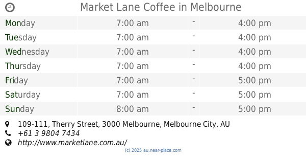
Market Lane Coffee
109-111 Therry Street, Melbourne
Cafe
read more
962 m
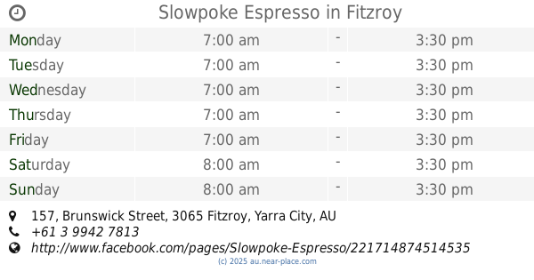
Slowpoke Espresso
157 Brunswick Street, Fitzroy
Cafe
read more
984 m
Gong Cha
429 Elizabeth Street, Melbourne
Cafe
read more
1.015 km
Supagrind
1/21 Lonsdale Street, Melbourne
Cafe
read more
1.12 km
PHANCY CAFE & CATERING
410 Queen Street, Melbourne
Cafe
read more
1.128 km
Merlo Coffee
Queen Victoria Market, Peel Street, Melbourne
Cafe
read more
1.143 km
Phancy Cafe & Catering
408 Queen Street, Melbourne
Cafe
read more
1.166 km
Grace
76 Rose Street, Fitzroy
Cafe
read more
📑
all categories
Accounting
Administrative area level 1
Administrative area level 2
Airport
Amusement park
Aquarium
Art gallery
Atm
Bakery
Bank
Bar
Beauty salon
Bicycle store
Book store
Bowling alley
Bus station
Cafe
Campground
Car dealer
Car rental
Car repair
Car wash
Casino
Cemetery
Church
City hall
Clothing store
Colloquial area
Convenience store
Courthouse
Dentist
Department store
Doctor
Electrician
Electronics store
Embassy
Finance
Fire station
Florist
Food
Funeral home
Furniture store
Gas station
General contractor
Grocery or supermarket
Gym
Hair care
Hardware store
Health
Hindu Temple
Home goods store
Hospital
Insurance agency
Jewelry store
Laundry
Lawyer
Library
Light rail station
Liquor store
Local government office
Locality
Locksmith
Lodging
Meal delivery
Meal takeaway
Mosque
Movie rental
Movie theater
Moving company
Museum
Natural feature
Neighborhood
Night club
Painter
Park
Parking
Pet store
Pharmacy
Physiotherapist
Place of worship
Plumber
Point of interest
Police
Political
Post office
Premise
Real estate agency
Restaurant
Roofing contractor
Route
Rv park, camping
School
Shoe store
Shopping mall
Spa
Stadium
Storage
Store
Subpremise
Subway station
Supermarket
Synagogue
Taxi stand
Train station
Transit station
Travel agency
University
Veterinary care
Zoo
↑