Gas station nearby BP
Coronavirus disease (COVID-19) Situation
confirmed cases
11853144
deaths
24414
Australia
Gas station nearby BP
BP
1067 Captain Cook Highway, Smithfield Australia
contacts phone
:
+61
Latitude:
-16.8292237
, Longitude:
145.6922104
read more
nearest Gas station
6.716 km
Mobil
4/2 Rinks Close, Stratford
Gas station
read more
6.841 km
Puma
45 Arnold Street, Aeroglen
Gas station
read more
8.788 km
Mobil
2/101 Brinsmead Road, Brinsmead
Gas station
read more
9.589 km
Edge Hill Service Station
134 Collins Avenue, Edge Hill
Gas station
read more
10.803 km
Caltex
35 Reservoir Road, Cairns
Gas station
read more
11.25 km
Coles Express Cairns
58 Pease Street, Manunda
Gas station
read more
11.395 km
Shell
291 Sheridan Street, Cairns North
Gas station
read more
11.892 km
BP
Alfred Sydney & Mayer Sts, Manunda
Gas station
read more
11.894 km
BP
Alfred St &, Mayers Street, Manunda
Gas station
read more
11.921 km
Woolworths Caltex
33/63 Alfred Street, Manunda
Gas station
read more
11.937 km
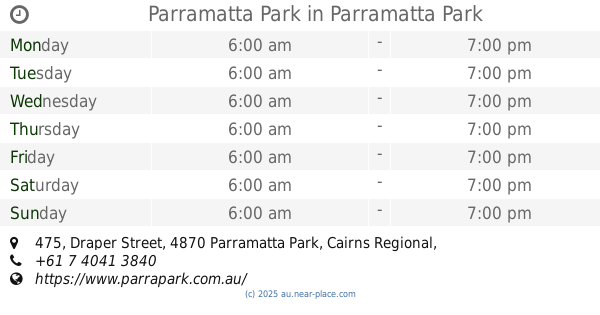
Parramatta Park
471/475 Draper Street, Parramatta Park
Gas station
read more
12.462 km
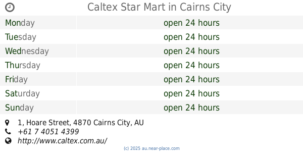
Caltex Star Mart
1 Hoare Street, Cairns City
Gas station
read more
13.181 km
BP
Florence Street, Cairns North
Gas station
read more
13.465 km
BP
395 Mulgrave Road, Bungalow
Gas station
read more
13.832 km
Caltex Woolworths
541 Mulgrave Road, Earlville
Gas station
read more
13.902 km
Buchan St Service Centre
129 Buchan Street, Bungalow
Gas station
read more
13.909 km
BP
Spence & Buchan Sts, Bungalow
Gas station
read more
14.358 km
Cairns Cvro
CNR Kenny ST & Draper ST, Cairns City
Gas station
read more
14.361 km
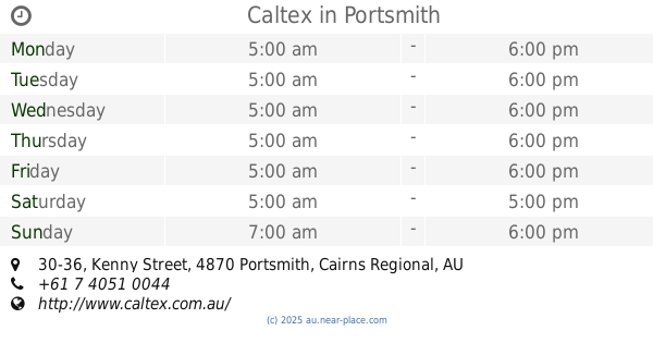
Caltex
30-36 Kenny Street, Portsmith
Gas station
read more
14.442 km
F1 Fuel & Lubrication
4870, 10 Knight Street, Portsmith
Gas station
read more
14.561 km
Caltex Cairns
60-88 Draper Street, Cairns
Gas station
read more
15.104 km
Puma Portsmith
104 Cook Street, Portsmith
Gas station
read more
15.132 km
United
6 Southgate Close, Woree
Gas station
read more
15.159 km
Puma Woree
656-658 Bruce Highway, Woree
Gas station
read more
15.22 km
Fuchs
87 Cook Street, Portsmith
Gas station
read more
📑
all categories
Accounting
Administrative area level 1
Administrative area level 2
Airport
Amusement park
Aquarium
Art gallery
Atm
Bakery
Bank
Bar
Beauty salon
Bicycle store
Book store
Bowling alley
Bus station
Cafe
Campground
Car dealer
Car rental
Car repair
Car wash
Casino
Cemetery
Church
City hall
Clothing store
Colloquial area
Convenience store
Courthouse
Dentist
Department store
Doctor
Electrician
Electronics store
Embassy
Finance
Fire station
Florist
Food
Funeral home
Furniture store
Gas station
General contractor
Grocery or supermarket
Gym
Hair care
Hardware store
Health
Hindu Temple
Home goods store
Hospital
Insurance agency
Jewelry store
Laundry
Lawyer
Library
Light rail station
Liquor store
Local government office
Locality
Locksmith
Lodging
Meal delivery
Meal takeaway
Mosque
Movie rental
Movie theater
Moving company
Museum
Natural feature
Neighborhood
Night club
Painter
Park
Parking
Pet store
Pharmacy
Physiotherapist
Place of worship
Plumber
Point of interest
Police
Political
Post office
Premise
Real estate agency
Restaurant
Roofing contractor
Route
Rv park, camping
School
Shoe store
Shopping mall
Spa
Stadium
Storage
Store
Subpremise
Subway station
Supermarket
Synagogue
Taxi stand
Train station
Transit station
Travel agency
University
Veterinary care
Zoo
↑