Gas station nearby BP
Coronavirus disease (COVID-19) Situation
confirmed cases
11853144
deaths
24414
Australia
Gas station nearby BP
BP
17 Bridge Street, Tamworth Australia
contacts phone
:
+61
Latitude:
-31.0912099
, Longitude:
150.924989
read more
nearest Gas station
4 m
BP
17 Bridge Street, West Tamworth
Gas station
read more
664 m
BP
190 Peel Street, Tamworth
Gas station
read more
694 m
Shell
147/152 Bridge Street, West Tamworth
Gas station
read more
825 m
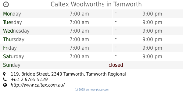
Caltex Woolworths
119 Bridge Street, Tamworth
Gas station
read more
887 m
Caltex Tamworth Orana
21 White St Cnr, Marius Street, Tamworth
Gas station
read more
890 m
Caltex
239 Marius Street, Tamworth
Gas station
read more
1.09 km
Caltex Tamworth Diesel Stop
47 Plain Street, Tamworth
Gas station
read more
1.09 km
Caltex
47 Plain Street, Tamworth
Gas station
read more
1.379 km
Nortam Service Station
24 North Street, North Tamworth
Gas station
read more
1.5 km
Caltex Tamworth Southgate
Kent St Cnr Kathleen St, Tamworth
Gas station
read more
1.524 km
Proposed Kennards Hire
14-16 Lockheed Street, Taminda
Gas station
read more
1.643 km
Shell Tamworth West
9/13 Gunnedah Road, West Tamworth
Gas station
read more
1.914 km
BP
27/29 Gunnedah Road, Taminda
Gas station
read more
1.916 km
BP Lowes Petroleum Service
27-29 Gunnedah Road, Tamworth
Gas station
read more
2.305 km
Coles Express
251 Goonoo Goonoo Road, South Tamworth
Gas station
read more
2.307 km
Shell
251/253 Goonoo Goonoo Road, South Tamworth
Gas station
read more
2.901 km
Caltex Tamworth
109 Gunnedah Road, Taminda
Gas station
read more
2.901 km
Caltex
109 Gunnedah Road, Taminda
Gas station
read more
3.054 km
Rex' Motors
Werris Creek Rd, Tamworth
Gas station
read more
3.06 km
Liberty
68 Duri Road, South Tamworth
Gas station
read more
3.061 km
Neumann Petroleum
68 Duri Road, South Tamworth
Gas station
read more
3.065 km
Matilda Blue
68 Duri Road, South Tamworth
Gas station
read more
3.895 km
BP
399 Goonoo Goonoo Road, Tamworth
Gas station
read more
4.316 km
Metro Tamworth
Armidale Road, East Tamworth
Gas station
read more
4.316 km
Metro Tamworth
360 Armidale Road, East Tamworth
Gas station
read more
📑
all categories
Accounting
Administrative area level 1
Administrative area level 2
Airport
Amusement park
Aquarium
Art gallery
Atm
Bakery
Bank
Bar
Beauty salon
Bicycle store
Book store
Bowling alley
Bus station
Cafe
Campground
Car dealer
Car rental
Car repair
Car wash
Casino
Cemetery
Church
City hall
Clothing store
Colloquial area
Convenience store
Courthouse
Dentist
Department store
Doctor
Electrician
Electronics store
Embassy
Finance
Fire station
Florist
Food
Funeral home
Furniture store
Gas station
General contractor
Grocery or supermarket
Gym
Hair care
Hardware store
Health
Hindu Temple
Home goods store
Hospital
Insurance agency
Jewelry store
Laundry
Lawyer
Library
Light rail station
Liquor store
Local government office
Locality
Locksmith
Lodging
Meal delivery
Meal takeaway
Mosque
Movie rental
Movie theater
Moving company
Museum
Natural feature
Neighborhood
Night club
Painter
Park
Parking
Pet store
Pharmacy
Physiotherapist
Place of worship
Plumber
Point of interest
Police
Political
Post office
Premise
Real estate agency
Restaurant
Roofing contractor
Route
Rv park, camping
School
Shoe store
Shopping mall
Spa
Stadium
Storage
Store
Subpremise
Subway station
Supermarket
Synagogue
Taxi stand
Train station
Transit station
Travel agency
University
Veterinary care
Zoo
↑