Gas station nearby Food To Fuel
Australia
Gas station nearby Food To Fuel
Food To Fuel
382 Darling Street, Balmain Australia
contacts phone
:
+61
Latitude:
-33.8562094
, Longitude:
151.1758016
read more
nearest Gas station
976 m
Caltex Woolworths Rozelle
121 Victoria Road, Rozelle
Gas station
read more
976 m
Caltex Woolworths
121 Victoria Road, Rozelle
Gas station
read more
994 m
United
127 Victoria Road, Rozelle
Gas station
read more
1.034 km
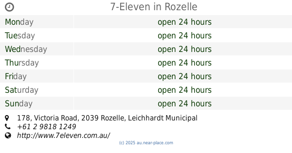
7-Eleven Rozelle
178-184 Victoria Road &, Moodie Street, Rozelle
Gas station
read more
1.034 km
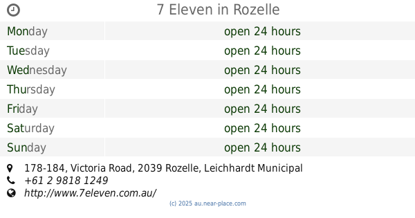
7-Eleven
178-184 Victoria Road &, Moodie Street, Rozelle
Gas station
read more
1.042 km
7-Eleven Rozelle
178-184 Victoria Road, Rozelle
Gas station
read more
1.042 km
7-Eleven
178 Victoria Road, Rozelle
Gas station
read more
1.042 km
7 Eleven
178-184 Victoria Road, Rozelle
Gas station
read more
1.085 km
BP
Victoria Rd &, Evans Street, Rozelle
Gas station
read more
1.085 km
BP
Victoria Road, Rozelle
Gas station
read more
1.52 km
Shell
36-46 Victoria Road, Drummoyne
Gas station
read more
1.524 km
Coles Express
38-46 Victoria Road, Drummoyne
Gas station
read more
1.564 km
Coles Express
35/51 Victoria Road, Drummoyne
Gas station
read more
1.576 km
Coles Express
39- 51 Victoria Road, Drummoyne
Gas station
read more
2.745 km
Caltex
191-195 Lyons Road, Drummoyne
Gas station
read more
2.784 km
Coles Express
124/126 Johnston Street, Annandale
Gas station
read more
2.784 km
Shell
124/126 Johnston Street, Annandale
Gas station
read more
2.788 km
Coles Express
124-126 Johnston St, Annandale
Gas station
read more
3.404 km
Shell
387 Wattle St, Cnr Kelly St, Ultimo
Gas station
read more
3.417 km
Coles Express
387/427 Wattle Street, Ultimo
Gas station
read more
4.153 km
Budget Petrol
52/54 Crystal Street, Petersham
Gas station
read more
4.329 km
7-Eleven
231-235 Great North Road, Five Dock
Gas station
read more
4.579 km
Caltex Woolworths
774 Parramatta Road, Lewisham
Gas station
read more
4.844 km
Burwood Petroleum
273 Parramatta Road, Haberfield
Gas station
read more
4.882 km
Metro
165 Parramatta Road, Haberfield
Gas station
read more
📑
all categories
Accounting
Administrative area level 1
Administrative area level 2
Airport
Amusement park
Aquarium
Art gallery
Atm
Bakery
Bank
Bar
Beauty salon
Bicycle store
Book store
Bowling alley
Bus station
Cafe
Campground
Car dealer
Car rental
Car repair
Car wash
Casino
Cemetery
Church
City hall
Clothing store
Colloquial area
Convenience store
Courthouse
Dentist
Department store
Doctor
Electrician
Electronics store
Embassy
Finance
Fire station
Florist
Food
Funeral home
Furniture store
Gas station
General contractor
Grocery or supermarket
Gym
Hair care
Hardware store
Health
Hindu Temple
Home goods store
Hospital
Insurance agency
Jewelry store
Laundry
Lawyer
Library
Light rail station
Liquor store
Local government office
Locality
Locksmith
Lodging
Meal delivery
Meal takeaway
Mosque
Movie rental
Movie theater
Moving company
Museum
Natural feature
Neighborhood
Night club
Painter
Park
Parking
Pet store
Pharmacy
Physiotherapist
Place of worship
Plumber
Point of interest
Police
Political
Post office
Premise
Real estate agency
Restaurant
Roofing contractor
Route
Rv park, camping
School
Shoe store
Shopping mall
Spa
Stadium
Storage
Store
Subpremise
Subway station
Supermarket
Synagogue
Taxi stand
Train station
Transit station
Travel agency
University
Veterinary care
Zoo
↑