School nearby Geographe Primary School
Australia
School nearby Geographe Primary School
Geographe Primary School
Clydebank Avenue, Bovell Australia
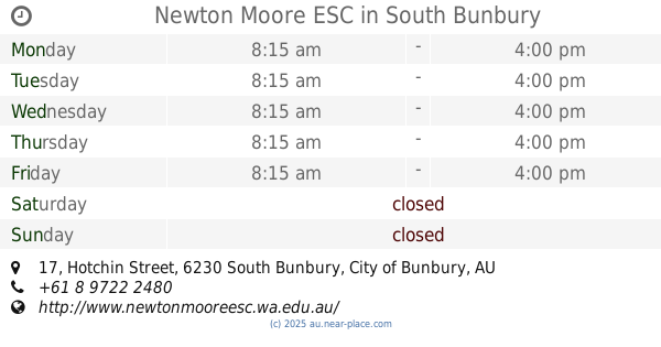
contacts phone
:
+61
Latitude:
-33.666597
, Longitude:
115.328508
read more
nearest School
403 m
St Mary MacKillop College
College Avenue, West Busselton
School
read more
1.102 km
Busselton Senior High School
136-156 Bussell Highway, Busselton
School
read more
1.177 km
Busselton Free Reformed Church
Pettit Crescent, West Busselton
School
read more
1.213 km
Goodstart Early Learning Busselton
1-7 Bovell Street, Busselton
School
read more
1.506 km
Dance Divine Studio & Fitness Centre
2/56 Bussell Highway, Busselton
School
read more
1.785 km
West Busselton Primary School
11-17 Bower Road, Busselton
School
read more
1.81 km
Rural Clinical School Of Western Australia
76 Gale Street, West Busselton
School
read more
1.951 km
St Joseph's School
Albert Street, Busselton
School
read more
2.089 km
Kindermusik- Trudys Music For Little Mozarts
19/21 Kent Street, Busselton
School
read more
5.04 km
Georgiana Molloy Anglican School
2 Hawker Approach, Yalyalup
School
read more
5.401 km
Busselton Primary School
25 Armitage Drive, Geographe
School
read more
7.225 km
George and liam
33 Spinnaker Boulevard, Geographe
School
read more
40.293 km
Dalyellup Primary School
14 Hartog Road, Dalyellup
School
read more
44.355 km
Newton Moore Senior High School
19-35 Hotchin Street, South Bunbury
School
read more
44.365 km
Newton Moore ESC
17 Hotchin Street, South Bunbury
School
read more
44.867 km
Rural Clinical School of WA, Bunbury
College Grove
School
read more
46.425 km
Ride On Motorcycle School
73 Tuart Street, South Bunbury
School
read more
46.496 km
St Marys Catholic Primary
18 Mary Street, South Bunbury
School
read more
46.648 km
Integrative Wellness & Yoga
level 1/123 Spencer Street, Bunbury
School
read more
46.675 km
Carey Park Scouts
75 Wisbey Street, Carey Park
School
read more
47.07 km
Coastal Water Dive
3/87 Albert Road, East Bunbury
School
read more
47.304 km
Rock 'N' Roll High School
16 Zoe Street, Bunbury
School
read more
48.995 km
Grace Christian School
22 Vittoria Road, Bunbury
School
read more
49.283 km
GEMS Prep School
128 Jeffrey Road, Glen Iris
School
read more
49.316 km
Picton Primary School
125 Jeffrey Road, Glen Iris
School
read more
📑
all categories
Accounting
Administrative area level 1
Administrative area level 2
Airport
Amusement park
Aquarium
Art gallery
Atm
Bakery
Bank
Bar
Beauty salon
Bicycle store
Book store
Bowling alley
Bus station
Cafe
Campground
Car dealer
Car rental
Car repair
Car wash
Casino
Cemetery
Church
City hall
Clothing store
Colloquial area
Convenience store
Courthouse
Dentist
Department store
Doctor
Electrician
Electronics store
Embassy
Finance
Fire station
Florist
Food
Funeral home
Furniture store
Gas station
General contractor
Grocery or supermarket
Gym
Hair care
Hardware store
Health
Hindu Temple
Home goods store
Hospital
Insurance agency
Jewelry store
Laundry
Lawyer
Library
Light rail station
Liquor store
Local government office
Locality
Locksmith
Lodging
Meal delivery
Meal takeaway
Mosque
Movie rental
Movie theater
Moving company
Museum
Natural feature
Neighborhood
Night club
Painter
Park
Parking
Pet store
Pharmacy
Physiotherapist
Place of worship
Plumber
Point of interest
Police
Political
Post office
Premise
Real estate agency
Restaurant
Roofing contractor
Route
Rv park, camping
School
Shoe store
Shopping mall
Spa
Stadium
Storage
Store
Subpremise
Subway station
Supermarket
Synagogue
Taxi stand
Train station
Transit station
Travel agency
University
Veterinary care
Zoo
↑