Store nearby the Lott
Coronavirus disease (COVID-19) Situation
confirmed cases
11853144
deaths
24414
Australia
Store nearby the Lott
the Lott
Firle Newsagency, Shop 7 / 193 Glynburn Road, Firle Australia
contacts phone
:
+61
Latitude:
-34.9056204
, Longitude:
138.6575635
read more
nearest Store
63 m
St Bernards Fruit And Veg Continental
4/171 Glynburn Road, Firle
Store
read more
66 m
Firle Fresh Fruiters
4/171 Glynburn Road, Firle
Store
read more
82 m
SA Lotteries
171 Glynburn Road, Firle
Store
read more
90 m
EB Games Firle
Firle Plaza Shopping Centre, 9/171 Glynburn Road, Firle
Store
read more
150 m
Bargain City
Firle
Store
read more
178 m
Bargin City Firle PTY Ltd.
14/171 Glynburn Road, Firle
Store
read more
178 m
Proficient & Loyal Hearing Services
1/171 Glynburn Road, Firle
Store
read more
183 m
The Optical Superstore
171 Glynburn Road, Firle
Store
read more
184 m
OPSM Firle
K-Mart Plaza, 17/171 Glynburn Road, Firle
Store
read more
194 m
Natural Food Barn
Firle Plaza Shopping Centre, 23/171 Glynburn Road, Firle
Store
read more
239 m
The Eyewear Gallery
151 Glynburn Road, Firle
Store
read more
266 m
Campbelltown Sports Store
6/219 Glynburn Road, Saint Morris
Store
read more
924 m
Imperia
423 Magill Road, Saint Morris
Store
read more
967 m
Gotcha Fishing Tackle
413 Magill Road, Saint Morris
Store
read more
970 m
AVD Communications
426 Magill Road, Kensington Gardens
Store
read more
970 m
Little Black Box
426 Magill Road, Kensington Gardens
Store
read more
984 m
Gotcha Fishing Tackle (formerly "Got One")
413 Magill Road, Saint Morris
Store
read more
1.03 km
Mega Health
395 Magill Road, Saint Morris
Store
read more
1.06 km
Bon Vivant Good Living
391 Magill Road, Saint Morris
Store
read more
1.077 km
Anything Tennis
Crn Albermarle Ave and, Hereford Avenue, Adelaide
Store
read more
1.161 km
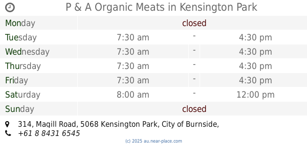
P & A Organic Meats
314 Magill Road, Kensington Park
Store
read more
1.178 km
Ivana Designs
316 Magill Road, Kensington Park
Store
read more
1.333 km
Flamingo Signs & Designs
319 Magill Road, Trinity Gardens
Store
read more
2.065 km
Amfac Chemdata
258 Payneham Road, Payneham
Store
read more
2.602 km
Chicken Made Easy
24/161 The Parade, Norwood
Store
read more
📑
all categories
Accounting
Administrative area level 1
Administrative area level 2
Airport
Amusement park
Aquarium
Art gallery
Atm
Bakery
Bank
Bar
Beauty salon
Bicycle store
Book store
Bowling alley
Bus station
Cafe
Campground
Car dealer
Car rental
Car repair
Car wash
Casino
Cemetery
Church
City hall
Clothing store
Colloquial area
Convenience store
Courthouse
Dentist
Department store
Doctor
Electrician
Electronics store
Embassy
Finance
Fire station
Florist
Food
Funeral home
Furniture store
Gas station
General contractor
Grocery or supermarket
Gym
Hair care
Hardware store
Health
Hindu Temple
Home goods store
Hospital
Insurance agency
Jewelry store
Laundry
Lawyer
Library
Light rail station
Liquor store
Local government office
Locality
Locksmith
Lodging
Meal delivery
Meal takeaway
Mosque
Movie rental
Movie theater
Moving company
Museum
Natural feature
Neighborhood
Night club
Painter
Park
Parking
Pet store
Pharmacy
Physiotherapist
Place of worship
Plumber
Point of interest
Police
Political
Post office
Premise
Real estate agency
Restaurant
Roofing contractor
Route
Rv park, camping
School
Shoe store
Shopping mall
Spa
Stadium
Storage
Store
Subpremise
Subway station
Supermarket
Synagogue
Taxi stand
Train station
Transit station
Travel agency
University
Veterinary care
Zoo
↑