Cafe nearby Attitude Coffee
Australia
Cafe nearby Attitude Coffee
Attitude Coffee
Albion Australien
contacts phone
:
+61
Latitude:
-27.4317485
, Longitude:
153.039589
read more
nearest Cafe
568 m
Fonzie Abbott Coffee Roasters
2/45 Crosby Road, Albion
Cafe
read more
571 m
Fonzie Abbott
40 Fox Street, Albion
Cafe
read more
833 m
Moto Zooma's
41 Allison Street, Bowen Hills
Cafe
read more
845 m
The Green Edge
2b/229 Lutwyche Road, Windsor
Cafe
read more
946 m
The Low Road Cafe & Bar
25 Eildon Road, Windsor
Cafe
read more
1.153 km
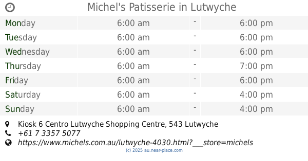
Michel's Patisserie
Kiosk 6 Centro Lutwyche Shopping Centre, 543 Lutwyche Rd, Lutwyche
Cafe
read more
1.153 km
Merlo Coffee
10 Thompson Street, Bowen Hills
Cafe
read more
1.17 km
My Mistress
515 Sandgate Road, Clayfield
Cafe
read more
1.242 km
Wanderer Coffee Newstead
41 Ross Street, Newstead
Cafe
read more
1.259 km
Laneway Coffee Roasters
28/29 Wickham Grove, Newstead
Cafe
read more
1.359 km
Blue Door Cafe
10 Ross Street, Newstead
Cafe
read more
1.406 km
The Colombian Coffee Dealer
65 Abbotsford Road, Bowen Hills
Cafe
read more
1.553 km
Harry's Diner
14/104 Newmarket Road, Windsor
Cafe
read more
1.764 km
Bowen Arrow Cafe
Madison Heights Apartments, 35 Campbell Street, Bowen Hills
Cafe
read more
1.797 km
The Oldstead
25 Evelyn Street, Newstead
Cafe
read more
1.82 km
Big Tree Bistro
Unit 1/69 Montpelier Road, Bowen Hills
Cafe
read more
1.932 km
Cafe 63 Wilston
83 Kedron Brook Road, Wilston
Cafe
read more
1.958 km
CBD Cafe Newstead
Shop 1/26 Reddacliff Street, Newstead
Cafe
read more
1.96 km
31/8
Wooloowin
Cafe
read more
1.96 km
Alcove Cafe and Deli
92 Kedron Brook Road, Wilston
Cafe
read more
2.046 km
Wandering Bull Espresso
695 Sandgate Road, Clayfield
Cafe
read more
2.082 km
Ohio Cafe & Restaurant
699 Sandgate Road, Clayfield
Cafe
read more
2.205 km
S Bar Cafe & Restaurant
742 Sandgate Road, Clayfield
Cafe
read more
2.384 km
Site Cafe - Coffee Shops Brisbane
banyo
Cafe
read more
2.409 km
Cafe Gia
132 Butterfield Street, Herston
Cafe
read more
📑
all categories
Accounting
Administrative area level 1
Administrative area level 2
Airport
Amusement park
Aquarium
Art gallery
Atm
Bakery
Bank
Bar
Beauty salon
Bicycle store
Book store
Bowling alley
Bus station
Cafe
Campground
Car dealer
Car rental
Car repair
Car wash
Casino
Cemetery
Church
City hall
Clothing store
Colloquial area
Convenience store
Courthouse
Dentist
Department store
Doctor
Electrician
Electronics store
Embassy
Finance
Fire station
Florist
Food
Funeral home
Furniture store
Gas station
General contractor
Grocery or supermarket
Gym
Hair care
Hardware store
Health
Hindu Temple
Home goods store
Hospital
Insurance agency
Jewelry store
Laundry
Lawyer
Library
Light rail station
Liquor store
Local government office
Locality
Locksmith
Lodging
Meal delivery
Meal takeaway
Mosque
Movie rental
Movie theater
Moving company
Museum
Natural feature
Neighborhood
Night club
Painter
Park
Parking
Pet store
Pharmacy
Physiotherapist
Place of worship
Plumber
Point of interest
Police
Political
Post office
Premise
Real estate agency
Restaurant
Roofing contractor
Route
Rv park, camping
School
Shoe store
Shopping mall
Spa
Stadium
Storage
Store
Subpremise
Subway station
Supermarket
Synagogue
Taxi stand
Train station
Transit station
Travel agency
University
Veterinary care
Zoo
↑