Cafe nearby Chars Cafe
Australia
Cafe nearby Chars Cafe
Chars Cafe
189 Maitland Road, Mayfield Australien
contacts phone
:
+61
Latitude:
-32.8970836
, Longitude:
151.7366812
read more
nearest Cafe
33 m
Onyx Espresso Bar
191 Maitland Road, Mayfield
Cafe
read more
96 m
Side Pocket Espresso
292/286 Maitland Road, Mayfield
Cafe
read more
181 m
Michelle's on Victoria
141 Maitland Road, Mayfield
Cafe
read more
193 m
The Feed Bar
Maitland Road, Mayfield
Cafe
read more
221 m
The Oily May Espresso Bar
223 Maitland Road, Mayfield
Cafe
read more
263 m
The Nature's Cafe
3/224-228 Maitland Road, Mayfield
Cafe
read more
289 m
Mayfield Senior Citizens Centre
187 Hanbury Street, Mayfield
Cafe
read more
588 m
Ying King Cafe
164 Maitland Road, Mayfield
Cafe
read more
709 m
ZAAKI ESPRESSO
402a Maitland Road, Mayfield
Cafe
read more
715 m
Portafilter
2/16 Hanbury Street, Mayfield
Cafe
read more
763 m
Vincents at the Coliseum
122 Maitland Road, Mayfield
Cafe
read more
815 m
Kids of Thunder
114 Maitland Road, Mayfield
Cafe
read more
1.048 km
ZoRiley's Cafe
43 Station Street, Waratah
Cafe
read more
1.351 km
Equium Social
1/5 Maitland Road, Mayfield East
Cafe
read more
1.422 km
Bakers of Georgetown
41 Georgetown Road, Georgetown
Cafe
read more
1.426 km
The Oily George Espresso Bar
54 Georgetown Road, Georgetown
Cafe
read more
1.509 km
Gloria Jeans Coffee's Waratah Village
7/91 Turton Road, Waratah
Cafe
read more
1.566 km
Gloria Jean's Coffees
7/91 Turton Road, Waratah
Cafe
read more
1.955 km
Sunnyside Take Away
47 Broadmeadow Road, Broadmeadow
Cafe
read more
2.177 km
The Fernery
84 Fern Street, Islington
Cafe
read more
2.53 km
Suspension Espresso
3 Beaumont Street, Islington
Cafe
read more
2.57 km
The Tailor's Workshop
10 Beaumont Street, Islington
Cafe
read more
2.62 km
Darks Coffee
301 Turton Road, New Lambton
Cafe
read more
2.888 km
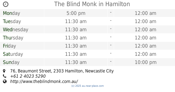
The Blind Monk
76 Beaumont Street, Hamilton
Cafe
read more
3.188 km
The Vintage Rose Cafe
128 Elder Street, Lambton
Cafe
read more
📑
all categories
Accounting
Administrative area level 1
Administrative area level 2
Airport
Amusement park
Aquarium
Art gallery
Atm
Bakery
Bank
Bar
Beauty salon
Bicycle store
Book store
Bowling alley
Bus station
Cafe
Campground
Car dealer
Car rental
Car repair
Car wash
Casino
Cemetery
Church
City hall
Clothing store
Colloquial area
Convenience store
Courthouse
Dentist
Department store
Doctor
Electrician
Electronics store
Embassy
Finance
Fire station
Florist
Food
Funeral home
Furniture store
Gas station
General contractor
Grocery or supermarket
Gym
Hair care
Hardware store
Health
Hindu Temple
Home goods store
Hospital
Insurance agency
Jewelry store
Laundry
Lawyer
Library
Light rail station
Liquor store
Local government office
Locality
Locksmith
Lodging
Meal delivery
Meal takeaway
Mosque
Movie rental
Movie theater
Moving company
Museum
Natural feature
Neighborhood
Night club
Painter
Park
Parking
Pet store
Pharmacy
Physiotherapist
Place of worship
Plumber
Point of interest
Police
Political
Post office
Premise
Real estate agency
Restaurant
Roofing contractor
Route
Rv park, camping
School
Shoe store
Shopping mall
Spa
Stadium
Storage
Store
Subpremise
Subway station
Supermarket
Synagogue
Taxi stand
Train station
Transit station
Travel agency
University
Veterinary care
Zoo
↑