Cafe nearby Faces and Places
Australia
Cafe nearby Faces and Places
Faces and Places
6 Errol Street, Melbourne Australia
contacts phone
:
+61
Latitude:
-37.80491
, Longitude:
144.949563
read more
nearest Cafe
340 m
Elceed
610 Queensberry Street, North Melbourne
Cafe
read more
387 m
Embassy Cafe
547 Spencer Street, West Melbourne
Cafe
read more
429 m
Cafe 6six 5fifty 5five
655 Spencer Street, West Melbourne
Cafe
read more
621 m
Merlo Coffee
Queen Victoria Market, Peel Street, Melbourne
Cafe
read more
622 m
Le Festin Cafe
shop 1/35-45 Dryburgh Street, West Melbourne
Cafe
read more
655 m
Roller Door Cafe
13 Stawell Street, West Melbourne
Cafe
read more
754 m
Shop30Coffee
1-7 O'connell Street, North Melbourne
Cafe
read more
882 m
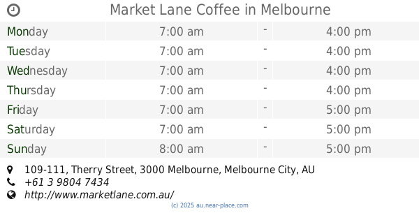
Market Lane Coffee
109-111 Therry Street, Melbourne
Cafe
read more
896 m
PHANCY CAFE & CATERING
410 Queen Street, Melbourne
Cafe
read more
901 m
Phancy Cafe & Catering
408 Queen Street, Melbourne
Cafe
read more
936 m
The Jazz Corner Cafe
350 William Street, Melbourne
Cafe
read more
939 m
Angliss Coffee Canery
Cafe
read more
967 m
Code 3
313 Spencer Street, Docklands
Cafe
read more
999 m
Jay's Coffee
295 William Street, Melbourne
Cafe
read more
1.037 km
Kings and Knaves Espresso
277 William Street, Melbourne
Cafe
read more
1.059 km
Gong Cha
429 Elizabeth Street, Melbourne
Cafe
read more
1.087 km
Unified Theory Specialty Coffee
270 King Street, Melbourne
Cafe
read more
1.114 km
Badger vs Hawk
333 La Trobe Street, Melbourne
Cafe
read more
1.114 km
Petty Session Cafe
255 William Street, Melbourne
Cafe
read more
1.135 km
Sarnies
550 Lonsdale Street, Melbourne
Cafe
read more
1.161 km
Brick Lane Cafe
33 Guildford Lane, Melbourne
Cafe
read more
1.216 km
Cafe Giraffe
302 Little Lonsdale Street, Melbourne
Cafe
read more
1.224 km
Kerbside Caffe
3/391 Little Lonsdale Street, Melbourne
Cafe
read more
1.326 km
A25 Pizzeria
3/399 Lonsdale Street, Melbourne
Cafe
read more
1.351 km
Sool Tong Korean and Japanese restaurant
207 Queen Street, Melbourne
Cafe
read more
📑
all categories
Accounting
Administrative area level 1
Administrative area level 2
Airport
Amusement park
Aquarium
Art gallery
Atm
Bakery
Bank
Bar
Beauty salon
Bicycle store
Book store
Bowling alley
Bus station
Cafe
Campground
Car dealer
Car rental
Car repair
Car wash
Casino
Cemetery
Church
City hall
Clothing store
Colloquial area
Convenience store
Courthouse
Dentist
Department store
Doctor
Electrician
Electronics store
Embassy
Finance
Fire station
Florist
Food
Funeral home
Furniture store
Gas station
General contractor
Grocery or supermarket
Gym
Hair care
Hardware store
Health
Hindu Temple
Home goods store
Hospital
Insurance agency
Jewelry store
Laundry
Lawyer
Library
Light rail station
Liquor store
Local government office
Locality
Locksmith
Lodging
Meal delivery
Meal takeaway
Mosque
Movie rental
Movie theater
Moving company
Museum
Natural feature
Neighborhood
Night club
Painter
Park
Parking
Pet store
Pharmacy
Physiotherapist
Place of worship
Plumber
Point of interest
Police
Political
Post office
Premise
Real estate agency
Restaurant
Roofing contractor
Route
Rv park, camping
School
Shoe store
Shopping mall
Spa
Stadium
Storage
Store
Subpremise
Subway station
Supermarket
Synagogue
Taxi stand
Train station
Transit station
Travel agency
University
Veterinary care
Zoo
↑