Cafe nearby Steam Haus
Australia
Cafe nearby Steam Haus
Steam Haus
206B Whatley Crescent, Maylands Australien
contacts phone
:
+61
Latitude:
-31.9282492
, Longitude:
115.8927351
read more
nearest Cafe
9 m
Sherbet Cafe & Bake Shop
206B Whatley Crescent, Maylands
Cafe
read more
27 m
Chapels on Whatley
196 Whatley Crescent, Maylands
Cafe
read more
61 m
Smoult's Larder
186 Whatley Crescent, Maylands
Cafe
read more
75 m
Mrs. S
178 Whatley Crescent, Maylands
Cafe
read more
133 m
Dôme Café - Maylands
219-221 Railway Parade, Maylands
Cafe
read more
137 m
Eat-Me Cafe at the Numtong
172 Whatley Crescent, Maylands
Cafe
read more
148 m
Friends Club
61 Eighth Avenue, Maylands
Cafe
read more
169 m
The Little Shop of Plenty
217 Railway Parade, Maylands
Cafe
read more
171 m
Milkd
45 Eight Avenue,, Maylands
Cafe
read more
183 m
Rotana Garden Cafe
42 Eighth Avenue, Maylands
Cafe
read more
225 m
Carraresi food & beverage
16 George Street, Maylands
Cafe
read more
252 m
Rifici Coffee Shop
Guildford Road, Maylands
Cafe
read more
298 m
JONUS CAFE
shop 11/168 Guildford Road, Maylands
Cafe
read more
382 m
Classic Gourmet Cafe
4/238 Guildford Road, Maylands
Cafe
read more
759 m
Annies Wood Fired Pizza Trailer
Bardon Park, 18 Eighth Avenue East, Maylands
Cafe
read more
979 m
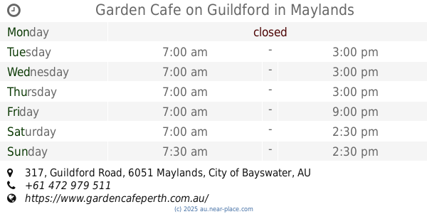
Garden Cafe on Guildford
317 Guildford Road, Maylands
Cafe
read more
980 m
Sugar & Nice
882 Beaufort Street, Inglewood
Cafe
read more
1.007 km
Jessie's Curry Kitchen & Cafe
869 Beaufort Street, Inglewood
Cafe
read more
1.022 km
MiaCafe
905 Beaufort Street, Inglewood
Cafe
read more
1.023 km
Joe Muggs Cafe
828 Beaufort Street, Inglewood
Cafe
read more
1.026 km
Mori Japanese Cuisine
1/895 Beaufort Street, Inglewood
Cafe
read more
1.027 km
PAWS cafe
3/885 Ninth Avenue, Inglewood
Cafe
read more
1.035 km
Tempting Tymes
885 Beaufort Street, Inglewood
Cafe
read more
1.041 km
Finlay & Sons
917 Beaufort Street, Inglewood
Cafe
read more
2.125 km
Howdy Coffee
11 King William Street, Bayswater
Cafe
read more
📑
all categories
Accounting
Administrative area level 1
Administrative area level 2
Airport
Amusement park
Aquarium
Art gallery
Atm
Bakery
Bank
Bar
Beauty salon
Bicycle store
Book store
Bowling alley
Bus station
Cafe
Campground
Car dealer
Car rental
Car repair
Car wash
Casino
Cemetery
Church
City hall
Clothing store
Colloquial area
Convenience store
Courthouse
Dentist
Department store
Doctor
Electrician
Electronics store
Embassy
Finance
Fire station
Florist
Food
Funeral home
Furniture store
Gas station
General contractor
Grocery or supermarket
Gym
Hair care
Hardware store
Health
Hindu Temple
Home goods store
Hospital
Insurance agency
Jewelry store
Laundry
Lawyer
Library
Light rail station
Liquor store
Local government office
Locality
Locksmith
Lodging
Meal delivery
Meal takeaway
Mosque
Movie rental
Movie theater
Moving company
Museum
Natural feature
Neighborhood
Night club
Painter
Park
Parking
Pet store
Pharmacy
Physiotherapist
Place of worship
Plumber
Point of interest
Police
Political
Post office
Premise
Real estate agency
Restaurant
Roofing contractor
Route
Rv park, camping
School
Shoe store
Shopping mall
Spa
Stadium
Storage
Store
Subpremise
Subway station
Supermarket
Synagogue
Taxi stand
Train station
Transit station
Travel agency
University
Veterinary care
Zoo
↑