Gas station nearby Plus Petrol
Australia
Gas station nearby Plus Petrol
Plus Petrol
403 Moreland Road, Coburg Australia
contacts phone
:
+61
Latitude:
-37.7528147
, Longitude:
144.9455399
read more
nearest Gas station
2 m
Tulloch Service Station
1 Melville Road, Pascoe Vale South
Gas station
read more
72 m
Caltex Safeway Coburg
430 Moreland Road, Coburg
Gas station
read more
1.923 km
Express Body Works
142 Dawson Street, Brunswick West
Gas station
read more
1.929 km
BP
142 Dawson Street, Brunswick West
Gas station
read more
2.276 km
Jet
35 Grantham Street, Brunswick West
Gas station
read more
2.284 km
Metro Petrol Station
157 Union Street, Brunswick West
Gas station
read more
2.379 km
Bike Repair Station
Upfield Bike Path, Brunswick
Gas station
read more
2.774 km
7 Eleven
556 Mount Alexander Road, Moonee Ponds
Gas station
read more
2.782 km
Caltex Woolworths
294-296 Ascot Vale Road, Moonee Ponds
Gas station
read more
2.811 km
Caltex Safeway Moonee Ponds
294-296 Ascot Vale Road, Moonee Ponds
Gas station
read more
2.861 km
Caltex
382 Lygon Street, Brunswick East
Gas station
read more
3.043 km
7-Eleven
Sydney Rd, Brunswick
Gas station
read more
3.043 km
7-Eleven Brunswick
Sydney Rd & Brunswick Rd, Brunswick
Gas station
read more
3.124 km
Coles Express
179-189 Lygon Street, Brunswick East
Gas station
read more
3.129 km
Shell
179-189 Glenlyon Rd & Lygon St, Brunswick East
Gas station
read more
3.421 km
Enhance Ascot Vale
195-199 Ascot Vale Road, Ascot Vale
Gas station
read more
3.637 km
Appartments
Nicholson Street, Brunswick East
Gas station
read more
4.339 km
Coles Express
485 Bell Street, Preston
Gas station
read more
4.716 km
BP
408 Bell Street, Preston
Gas station
read more
4.781 km
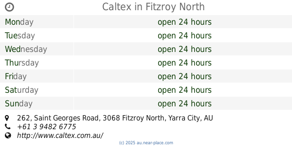
Caltex
262 Saint Georges Road, Fitzroy North
Gas station
read more
4.873 km
7-Eleven Thornbury
High Street, Thornbury
Gas station
read more
5.211 km
go go trailers
291 Nicholson Street, Carlton
Gas station
read more
5.35 km
Coles Express
cnr Elgin Streets, Carlton
Gas station
read more
6.089 km
7 Eleven
422-424 Hoddle St, Clifton Hill
Gas station
read more
6.176 km
Food Fuel Stop
65 Keele Street, Collingwood
Gas station
read more
📑
all categories
Accounting
Administrative area level 1
Administrative area level 2
Airport
Amusement park
Aquarium
Art gallery
Atm
Bakery
Bank
Bar
Beauty salon
Bicycle store
Book store
Bowling alley
Bus station
Cafe
Campground
Car dealer
Car rental
Car repair
Car wash
Casino
Cemetery
Church
City hall
Clothing store
Colloquial area
Convenience store
Courthouse
Dentist
Department store
Doctor
Electrician
Electronics store
Embassy
Finance
Fire station
Florist
Food
Funeral home
Furniture store
Gas station
General contractor
Grocery or supermarket
Gym
Hair care
Hardware store
Health
Hindu Temple
Home goods store
Hospital
Insurance agency
Jewelry store
Laundry
Lawyer
Library
Light rail station
Liquor store
Local government office
Locality
Locksmith
Lodging
Meal delivery
Meal takeaway
Mosque
Movie rental
Movie theater
Moving company
Museum
Natural feature
Neighborhood
Night club
Painter
Park
Parking
Pet store
Pharmacy
Physiotherapist
Place of worship
Plumber
Point of interest
Police
Political
Post office
Premise
Real estate agency
Restaurant
Roofing contractor
Route
Rv park, camping
School
Shoe store
Shopping mall
Spa
Stadium
Storage
Store
Subpremise
Subway station
Supermarket
Synagogue
Taxi stand
Train station
Transit station
Travel agency
University
Veterinary care
Zoo
↑