Lodging nearby Linbridgeford
Australia
Lodging nearby Linbridgeford
Linbridgeford
148, Princes Way, 3818, Drouin, Baw Baw Shire, AU Australia
contacts phone
:
+61 408 575 455
Latitude:
-38.1327995
, Longitude:
145.8530485
larger map & directions
read more
nearest Lodging
620 m
Drouin Royal Hotel PTY Ltd.
2/4 Main South Road, Drouin
Lodging
read more
652 m
The Royal hotel
2/4 Main South Road, Drouin
Lodging
read more
666 m
Ravenswood Accommodation
7 Main South Road, Drouin
Lodging
read more
1.337 km
Comfort Inn Drouin
275 Princes Way, Drouin
Lodging
read more
2.127 km
Marran House
885 Princes Way, Drouin
Lodging
read more
5.109 km
Robin Hood Inn
655 Princes Way, Drouin West
Lodging
read more
6.268 km
Comfort Inn & Suites Warragul
1845 Princes Way, Warragul
Lodging
read more
6.606 km
Fairway Views Accommodation
46 Sutton Street, Warragul
Lodging
read more
6.924 km
Edinburgh Motor Inn
61 Princes Way, Warragul
Lodging
read more
6.936 km
Lantilly House
3 Toorak Avenue, Warragul
Lodging
read more
7.247 km
Cora's Cottage
12 Church Street, Warragul
Lodging
read more
7.402 km
Balfour House
12 Edgar Road, Longwarry
Lodging
read more
7.438 km
Lawrence
6 Highclere Street, Warragul
Lodging
read more
7.521 km
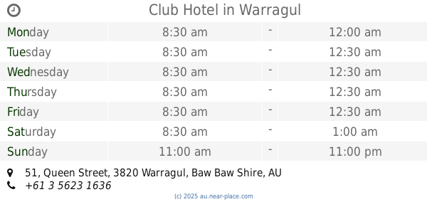
Club Hotel
51 Queen Street, Warragul
Lodging
read more
7.778 km
Longwarry Hotel
4 Kennedy St, Longwarry
Lodging
read more
7.79 km
Camellia Cottage on-the-Park
7 Kent Street, Warragul
Lodging
read more
7.82 km
Commercial Hotel
115 Queen Street, Warragul
Lodging
read more
7.891 km
Cooinda Lodge
41 Landsborough Street, Warragul
Lodging
read more
8.002 km
Valley View Cottage Warragul
336 Normanby Street, Warragul
Lodging
read more
8.103 km
mecure hotel
23 Mason Street, Warragul
Lodging
read more
8.121 km
Gracevale Lodge
133 Normanby Street, Warragul
Lodging
read more
8.623 km
Warragul Views Motor Inn
50 Rulemount Road, Warragul
Lodging
read more
9.385 km
Manderley Park Farmstay B & B
98 Ryans Road, Buln Buln
Lodging
read more
11.273 km
Bloomfield Cottages
147 No 1 Road, Nilma
Lodging
read more
13.663 km
Raglan Bed & Breakfast
Bona Vista Road, Bona Vista via Warragul
Lodging
read more
📑
all categories
Accounting
Administrative area level 1
Administrative area level 2
Airport
Amusement park
Aquarium
Art gallery
Atm
Bakery
Bank
Bar
Beauty salon
Bicycle store
Book store
Bowling alley
Bus station
Cafe
Campground
Car dealer
Car rental
Car repair
Car wash
Casino
Cemetery
Church
City hall
Clothing store
Colloquial area
Convenience store
Courthouse
Dentist
Department store
Doctor
Electrician
Electronics store
Embassy
Finance
Fire station
Florist
Food
Funeral home
Furniture store
Gas station
General contractor
Grocery or supermarket
Gym
Hair care
Hardware store
Health
Hindu Temple
Home goods store
Hospital
Insurance agency
Jewelry store
Laundry
Lawyer
Library
Light rail station
Liquor store
Local government office
Locality
Locksmith
Lodging
Meal delivery
Meal takeaway
Mosque
Movie rental
Movie theater
Moving company
Museum
Natural feature
Neighborhood
Night club
Painter
Park
Parking
Pet store
Pharmacy
Physiotherapist
Place of worship
Plumber
Point of interest
Police
Political
Post office
Premise
Real estate agency
Restaurant
Roofing contractor
Route
Rv park, camping
School
Shoe store
Shopping mall
Spa
Stadium
Storage
Store
Subpremise
Subway station
Supermarket
Synagogue
Taxi stand
Train station
Transit station
Travel agency
University
Veterinary care
Zoo
↑