Premise nearby Crushing Industries
Coronavirus disease (COVID-19) Situation
confirmed cases
11853144
deaths
24414
Australia
Premise nearby Crushing Industries
Crushing Industries
65, Victoria Street, 4740, Mackay, Mackay Regional, AU Australien
contacts phone
:
+61 7 4957 1500
Latitude:
-21.1416163
, Longitude:
149.1873762
larger map & directions
read more
nearest Premise
551 m
61 Gordon St
Mackay
Premise
read more
607 m
J
Mackay
Premise
read more
658 m
Staff Car Parking
Mackay
Premise
read more
855 m
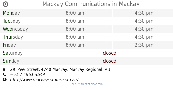
Mackay Communications
29 Peel Street, Mackay
Premise
read more
906 m
203 Victoria St
Mackay
Premise
read more
951 m
95 Gordon St
Mackay
Premise
read more
1.159 km
Showground
Mackay
Premise
read more
2.066 km
49 Malcomson St
North Mackay
Premise
read more
2.128 km
Palmview Village
North Mackay
Premise
read more
2.144 km
Park Haven
South Mackay
Premise
read more
2.472 km
South Mackay
South Mackay
Premise
read more
2.724 km
1 Bridge Rd
East Mackay
Premise
read more
3.428 km
The Shoals Park
Andergrove
Premise
read more
3.501 km
Lions Soccer Fields
Andergrove
Premise
read more
3.547 km
Mount Bassett Quarry
Mackay Harbour
Premise
read more
3.683 km
291 Milton St
South Mackay
Premise
read more
3.86 km
Theo Hanson Softball Oval
Andergrove
Premise
read more
3.88 km
Rental Cars Parking
South Mackay
Premise
read more
3.986 km
Long Term Parking
South Mackay
Premise
read more
3.987 km
Hotel Parking
South Mackay
Premise
read more
4.068 km
Traffic Control
285 Nebo Road, West Mackay
Premise
read more
4.353 km
Magpie Sporting Fields
Glenella
Premise
read more
4.649 km
229 Boundary Rd E
Paget
Premise
read more
4.68 km
Glenella State School
Glenella
Premise
read more
4.942 km
Sport Facility
Ooralea
Premise
read more
📑
all categories
Accounting
Administrative area level 1
Administrative area level 2
Airport
Amusement park
Aquarium
Art gallery
Atm
Bakery
Bank
Bar
Beauty salon
Bicycle store
Book store
Bowling alley
Bus station
Cafe
Campground
Car dealer
Car rental
Car repair
Car wash
Casino
Cemetery
Church
City hall
Clothing store
Colloquial area
Convenience store
Courthouse
Dentist
Department store
Doctor
Electrician
Electronics store
Embassy
Finance
Fire station
Florist
Food
Funeral home
Furniture store
Gas station
General contractor
Grocery or supermarket
Gym
Hair care
Hardware store
Health
Hindu Temple
Home goods store
Hospital
Insurance agency
Jewelry store
Laundry
Lawyer
Library
Light rail station
Liquor store
Local government office
Locality
Locksmith
Lodging
Meal delivery
Meal takeaway
Mosque
Movie rental
Movie theater
Moving company
Museum
Natural feature
Neighborhood
Night club
Painter
Park
Parking
Pet store
Pharmacy
Physiotherapist
Place of worship
Plumber
Point of interest
Police
Political
Post office
Premise
Real estate agency
Restaurant
Roofing contractor
Route
Rv park, camping
School
Shoe store
Shopping mall
Spa
Stadium
Storage
Store
Subpremise
Subway station
Supermarket
Synagogue
Taxi stand
Train station
Transit station
Travel agency
University
Veterinary care
Zoo
↑